From Crystal Lake CampGround to Jimmy Campground for
7.5 miles round trip
Leaving Sat Nov 5 and Returning Sunday Nov. 6
Cost for the trip is $20.00 per person.
* Troop Leaders and parents need to go and drive, please RSVP.
Bring lunch, we will eat on the trail up.
Meet at ONC Church at 9:00am
Return at Church Sunday at 1pm
Scout RSVP to Mr. Deveau no later than Thursday morning before by 7am.
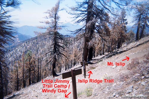
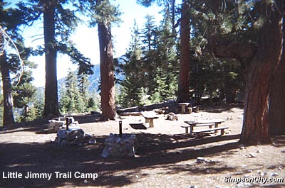
Jimmy Campground:
Hikers are rewarded with a splendid panoramic view
in all directions
The Little Jimmy campground is often used by the Scouts for overnight
camping expeditions and shake-down hikes.
This is a nice campground
with a spring and a pit toilet and, 16 hike-in table
campsites, A few old USFS stove
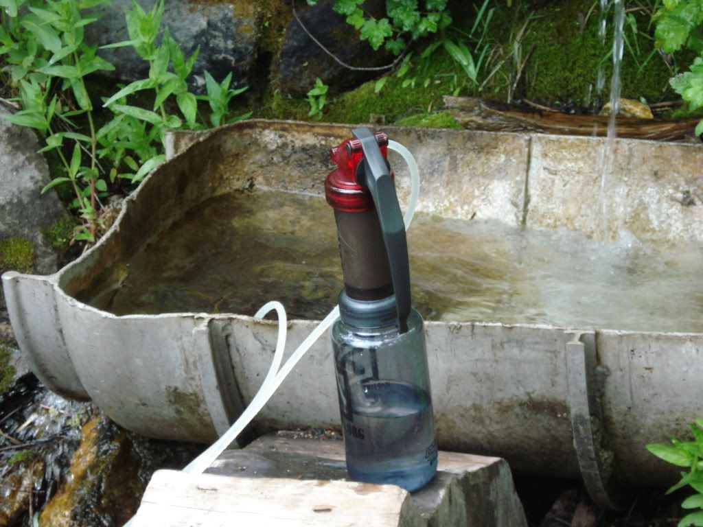
Water is available flowing from a pipe
at a developed spring about 1000 ft SE of the campground along the Pacific
Crest Trail; flow from the spring slows in late summer, but there has always
been water. Reservation no used.
Jimmy
Campground elevation is at 7,500 feet. 34.3475005,
-117.8300616
It is .2 miles to Jimmy Spring - water: Latitude.
34.34528°, Longitude. -117.82833°
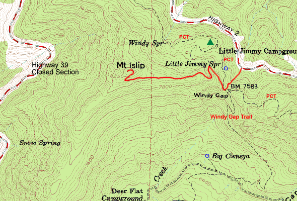
From Crystal Lake CampGround to Jimmy Campground for 7
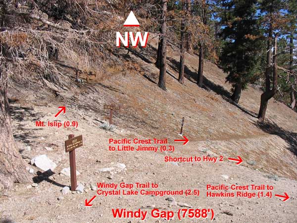
miles round trip. Windy Gap Trail
This Group will be coming in from the backside up the switchbacks.
Total Intermediate elevation gain of 2750 feet. Be in good
shape. In order to stay local and still get some elevation gain in our
hike we will be going up the backside to the Little Jimmy campground.
The trailhead for this hike starts at the Crystal Lake Campground at 5700
feet..
This is a pretty straightforward trip starting from the Crystal Lake
Picnic Parking Lot in Azusa Canyon we will hike to the northern end of
the campground to the trailhead. map
Our hike will take us down the trail, up the switchbacks and over the
pass (Windy Gap, 7588') to the Little Jimmy campground. Trial
sign
At Windy Gap the PTC - Pacific Crest Trail crosses the trail to Little Jimmy.
from Interstate 210 in Azusa, exit Azusa Ave. (Hwy. 39). Drive 25 miles north on on San Gabriel Can. Rd. (Hwy. 39) to the Crystal Lake entrance. Park in the large dirt clearing to the right just before the locked gate. Hike in from Crystal Lake - 3 miles.
Sunday we will hike out and on our way home.
_____________
(Maybe for some? Day hiking to the top of Mt. Baden-Powell 9,407 feet, again getting more elevation gain and miles under our feet.) Category: Very Strenuous
Or
Mt. Islip at 8250' page
map
_________________________
What to bring:
At least 2 liters of water
10 essentials except matches and map
Sleeping bag/ pad
Trail snacks
Bowl/spork
External backpack frame or an internal frame is acceptable,
and needed to properly carry all the gear.
Scouts will need to carry part of a tent and he may be
given food or fuel carry also.
Troop will provide:
Dinner on Saturday
Breakfast on Sunday
Water filter
Tents
Stoves
____
In spring or autumn nighttime temps will go below freezing -- you'll need a good sleeping bag...
More info:
From Crystal Lake CampGround to Jimmy Campground for
7 miles round trip
Crystal Lake to Little Jimmy Campground and back
7 miles round trip
2,200 feet elevation gain
Difficulty Rated: Moderate
Crystal Lake CampGround is at a elevation of 5700 feet (Latitude, Longitude):34.32556,
-117.83722
____
The Forest Service took advantage of the outstanding vantage point
of Mount Islip when it built a fire lookout on its summit in 1927, which
was moved to South Hawkins in 1937. The concrete footings of the tower
and the stone cabin shell still remain. The mountain gets its name from
George Islip, an early pioneer who homesteaded in the San Gabriel Canyon
in the 1880s.
_________
Hard snow or ice can linger on the steep, north-facing slopes until
sometime in May. You can avoid those areas by climbing straight up the
east ridge of Mt. Islip from Widy Gap. However, you may have snow in the
ravine Between Hwy 2 and Windy Gap.
___
[At 9,407 feet in elevation, Mount Baden-Powell is the 4th highest peak of the San Gabriel Range. Hike Category: Very Strenuous . map In 1957 several Southern California councils of the Boy Scouts of America placed a formal marker at the summit with a plaque dedicated to Lord Baden-Powell. Coordinates: 34°21 30 N 117°45 53 W ]
Photos (use back key to return)
Hike info
http://www.simpsoncity.com/hiking/islip.html
Enterance sign Crystal Lake
******************
Notes
_________
From Hwy 2 to to Jimmy Campground for 4 miles round trip
Note used on 2016 Trip:
From Hwy 2 to to Jimmy Campground for 4 miles round trip.
Coming from the Angeles Crest Highway this is a fairly easy hike. Total
easy elevation gain of 1000 feet.
Parking available approximately 2 miles down the trail at Islip Saddle
on Hwy 2 at 7250'
Access is via a trail from the parking lot at Islip Saddle on Hwy 2,
or from a dirt turnout about 1.3 miles east of Islip Saddle on the west
side of the road, up a dirt fire road that intersects the Pac Crest trail
(or you can just continue on the fire road, which parallels the trail 100
ft or so up the hill, to the campsite). About 2 mi from the highway via
either route.
Drive Location: From Interstate 210 in La Canada, exit at Angeles Crest
Hwy. (Hwy. 2) and drive 41 miles north to Islip Saddle. Cross the highway
and pick up the Pacific Crest Trail leading east. Follow the trail 2 miles.
Interagency Pass or Adventure Pass required to park at trailheads. Topo
Map - Topo
Map - map